
Protecting Thermal Refuges for Coldwater Fish in the PNW
April, 2024
By Davey French
Protecting thermal refuges is critical for coldwater fish in the PNW. Because fish are incapable of regulating their own body temperatures, they cue into thermal patterns to identify suitable habitat areas. A thermal refuge is an area of water with a difference of two degrees Celsius from the ambient temperature of surrounding water. While these can be a warm section in winter that provides metabolic advantages for rearing or foraging, stressors for coldwater fish in the PNW more typically involve increased water temperature during hot summer periods that drive them to seek out colder patches.
Thermal Refuges
Thermal refuges also vary in spatial scale, from entire tributaries to small spaces created by groundwater seeps or upwelling areas.
An EPA-funded study of thermal refuges, which was performed for the Puyallup Tribe by Natural Systems Design (NSD), focused on three basic questions:
- Where are thermal refuges?
- What are their geomorphic and hydrologic drivers?
- Are there opportunities for enhancing, creating protecting thermal refuges for the benefit of coldwater fish?
South Prairie Creek
South Prairie Creek in the Puyallup River watershed of northwest Washington State is a tributary to the Carbon River and an important sanctuary for numerous salmon species and resident coldwater fish. This watershed also lies in the traditional and current homelands of the Puyallup and Muckleshoot tribes.
Habitat availability in South Prairie Creek is impaired by warm summer stream temperatures, which are typically about five degrees warmer than the Carbon River. While stream impairment has many causes – including chemical and biological contaminants, land development, loss of tree cover and changes at the source or in the water volume – stream ecosystems are among the most sensitive to climate change. Impairment such as this is often the cause for fish and other aquatic organisms to seek a thermal refuge as protection from temperature extremes.
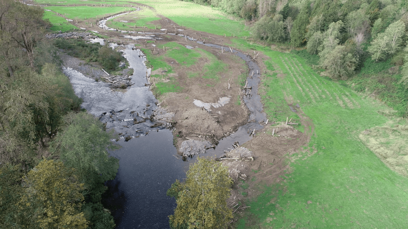
Spring Creek and South Prairie Creek Confluence
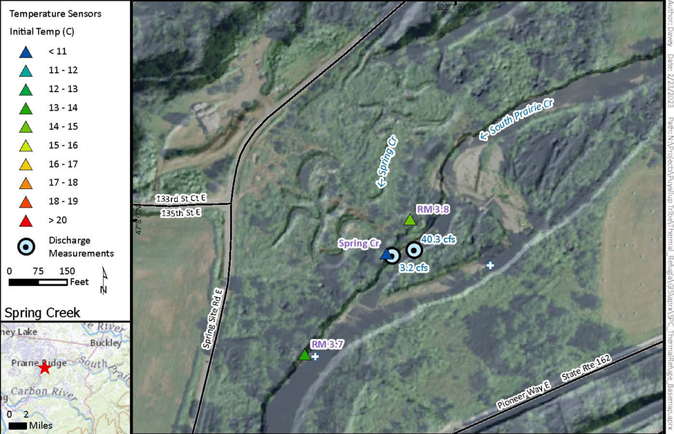
Spring Creek and South Prairie Creek confluence. Triangle points denote temperature sensor sites, and blue circles denote streamflow measurements.
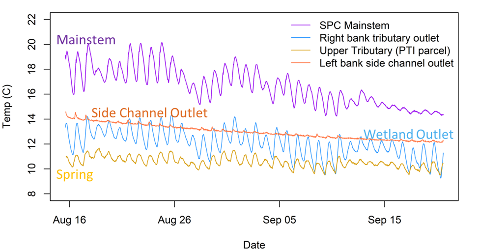
Spring Creek is consistently 10-12 degrees year-round, while South Prairie Creek exceeds 18-19 degrees in the summer.
Methodology
The first step in this data-driven project was to conduct a desktop analysis to review existing data and gather information from stakeholders in the basin. The study team then convened a technical workshop with outside experts to collect feedback on the proposed approach before gathering field data to support conceptual design.
The desktop work leveraged thermal infrared (TIR) data, which provided a snapshot of water surface temperatures. The data clearly showed cold areas within the broader background of warmer water. The team used lidar-derived canopy heights to assess stream shading and to understand where areas in the TIR data were potentially obscured by vegetation. This revealed opportunities for riparian restoration to improve shading.
Previous Assessments
Where available, the researchers also gathered information from previous assessments and project work. One previous dataset from 2014 illustrated a stark difference in temperature and water level variation between a spring-fed section known as Spring Creek, compared with the South Prairie Creek mainstem. While the spring-fed site showed relatively constant year-round temperatures and water levels, the latter’s water temperature generally tracked air temperature, and often exceeded water quality standards during the summer.
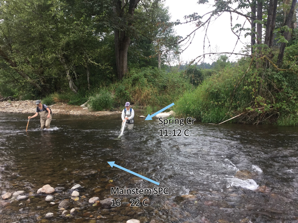
Confluence of Spring Creek and South Prairie Creek during summer 2022. Spring Creek is significantly cooler in the summer and warmer in the winter. Shown here are Kenna Patrick and Susan Dickerson-Lange.
The researchers focused on five sections of the basin for field data collection where they had high confidence that thermal refuges occurred and where access was permitted. The team performed rapid reconnaissance to measure temperature and identify potential thermal refuges, then returned a week later to conduct detailed measurements. This involved deploying temperature sensors at 30 locations, as well as measuring streamflow in mainstem channels, tributaries, and springs. The team also conducted detailed snorkel and habitat surveys in the five targeted sections.
Spring Creek
At Spring Creek, which accounts for just under 10% of overall flow in South Prairie Creek, researchers installed temperature sensors above its confluence with the South Prairie Creek mainstem, in the mouth of Spring Creek, and approximately 100 meters downstream of the confluence. Mainstem water temperatures recorded in August 2019 ranged from 14-22 degrees Celsius, while Spring Creek’s temperature remained a relatively constant 11-13 degrees Celsius. For a two-month assessment period, Spring Creek’s temperature averaged about 5 degrees cooler than the mainstem.
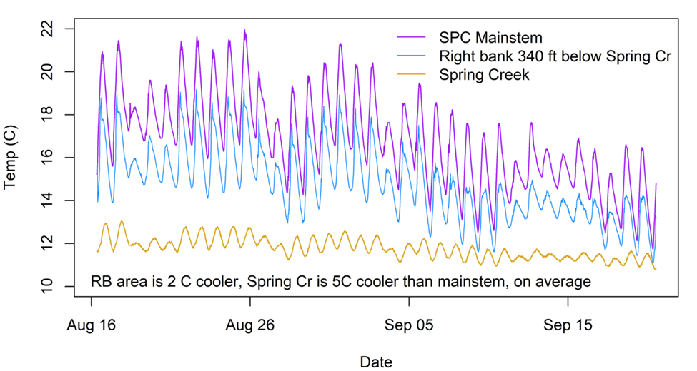
Temperature time series for South Prairie Creek above (purple) and below (blue) the confluence with Spring Creek (orange).
Data indicate that Spring Creek enters 5 degrees cooler than South Prairie Creek, and creates a cold plume of water that extends roughly 100 meters (340 feet) downstream.
Findings
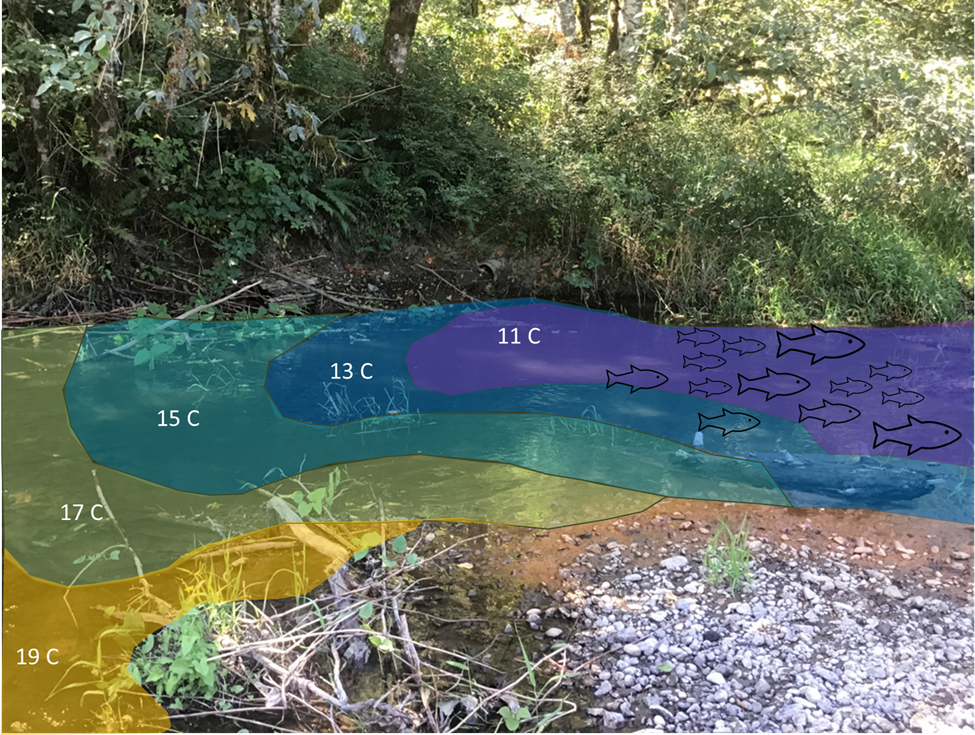
The sensors placed downstream of the Spring Creek mouth recorded temperatures about 2 degrees cooler than were found in the mainstem above the confluence. Data showed that the cooler Spring Creek flow created a cold plume extending about 100 meters long and 1-2 meters wide that hugged the right bank before mixing with warmer South Prairie Creek water and dissipating. This clearly constituted a thermal refuge, one of several the researchers documented.
Fowler Springs
At Fowler Springs, another spring-fed site on South Prairie Creek where similar conditions also create temperature variations, snorkel data indicated that fish congregate in thermal refuges where spring and groundwater flow are expressed. This and a substantial amount of additional data confirmed the following types of thermal regimes that exist in the subject area.
-
- Cold tributaries entering a warmer mainstem body
- Warm tributaries entering cooler mainstems
- Cooling side channel or hyporheic water where there are forested side channels
- Warming hyporheic flow as it moves through cobbles or substrate exposed to incoming sunlight in locations with unvegetated channels or bars
- Cooler water where hillslope or wetland seepage is found
- Alcove habitats fed by cool hyporheic flow
Temperature time series for South Prairie Creek above (purple) Fowler Springs outlet (blue). Fowler Springs at the hillslope (yellow) is consistently 10-12 degrees.
Hyporheic flow expressed from a forested side channel is also cool and shows limited diel variation, suggesting a strong groundwater signal.
Conclusion
Instream Actions to Protect and Enhance Thermal Refuges
These findings resulted in several potential instream actions that could protect and enhance thermal refuges.
Reduce Mixing Warmer Water
At Spring Creek during summer low flows, the 100-meter cold plume lies alongside an exposed bar with no shading or cover and very little habitat. One concept for enhancing this type of thermal refuge is to reduce the mixing in of warmer water by deflecting warm flow away from the cold tributary and by creating complex cover within the cold plume where fish can leverage the thermal refuge.
Increase Fish Access
For a site where cold hillslope seepage or springs contribute to coldwater habitat, hydrologists can implement strategies to increase fish access to cold floodplain wetlands or restore wetland habitat to increase hydrologic connectivity and coldwater habitat between coldwater sources and the mainstem.
Insert Structures that Deflect Flow
Where channel changes have reduced hyporheic or surface flow through forested side channels, one strategy could be to increase engagement of forested floodplain areas by inserting structures that deflect flow, locally raise water surface elevation, provide cover, and promote the development of forested islands that would improve riparian shading over time.
South Prairie Creek is culturally significant to first nation peoples and the present-day Puyallup Tribe. The creek’s salmon and the area’s other wildlife have always been and continue to be vital to their existence and identity. Ultimately, the goal of this effort is to protect and revitalize the ecosystem that supports the many species of salmon that spawn, rear, forage, migrate and overwinter in the waterway, but that is threatened by climate change and other manmade and natural influences.
Next Steps
The next steps in this initiative are to design and implement three pilot projects at high-priority sites, continue monitoring the data points established in the project, determine if and where fish are using these thermal refuges and explore other areas of the Puyallup River basin for thermal refuge restoration opportunities.
Thermal Deflector and Complex Edge Habitat ELJ
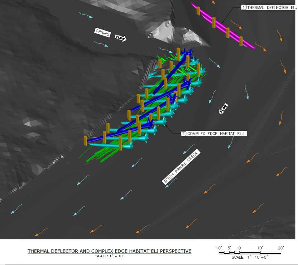
Conceptual design for a thermal deflector structure to reduce mixing of warm mainstem water and cooler tributary inflow.
A complex edge structure is intended to improve habitat and cover in the thermal refuge created by the cold water input.
Davey French
Davey French is an environmental and aquatic scientist with experience in freshwater and marine environments and human dimensions of natural resources. His enthusiasm for positive human-environment interactions shapes his approach to understanding and developing solutions that work for people, fish, and the landscape.
Davey’s experience spans from the North Pacific Ocean to remote regions of Alaska, Idaho, Eastern Washington and Oregon. He holds an MS from the School of Aquatic and Fishery Sciences and a BS from the School of Environmental and Forest Sciences at the University of Washington.