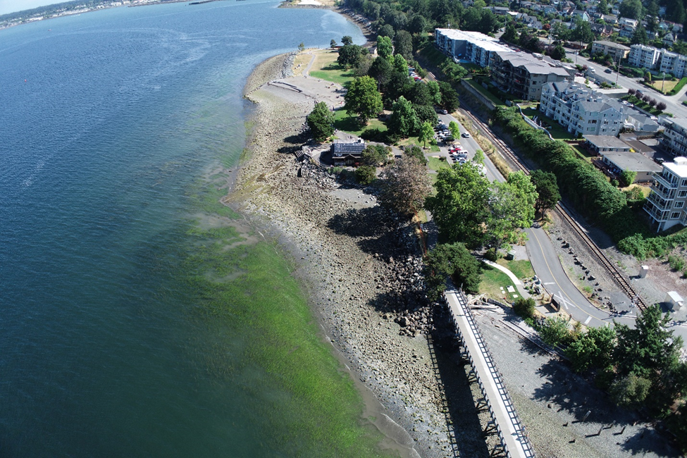
Enhancing the Shoreline at Beautiful Boulevard Park
June, 2024
By Will Templeton, Coastal Engineer, and Jim Johannessen, Principal Coastal Geologist
The Bellingham Herald calls Boulevard Park, “arguably the city’s most beloved and most popular park. This green space on the waterfront is one of the things that makes Bellingham a special place.” The Hotel Leo agrees that it is “probably the most popular Bellingham City Park.”
The park was “built on old coal mining, gas works and lumber mill property,” and 50 years ago it was “a wasteland,” Hotel Leo adds. But, in promoting the hotel’s location two miles from the park, its website gushes: “Today, thanks to the Greenways Levy and the vision of the Bellingham Park Department, [Boulevard Park] features beaches, an amazing over-water walkway, a popular café, extensive lawn, picnicking, a dock and a playground.”
Natural Systems Design is proud to have played a role in the park’s transformation. And, in conjunction with the recreational benefits of park improvements, our work has furthered the long-term and broader goal of adding and enhancing suitable salmon habitat along the northern coastline of Puget Sound.
Improvements Seen and Unseen
Our contributions at Boulevard Park include restoring natural coastal processes and improving intertidal and subtidal habitat for juvenile salmonids, forage fish and shellfish. Our current project involves restoring upland vegetation and providing upland space for recreation and cultural gatherings, while also improving shore erosion protection and flood prevention.
A goal of this ongoing coastal improvement project is to determine horizontal and vertical beach layout, as well as sediment characteristics suitable for habitat and sufficiently stable under wave attack and sea level rise. Success requires accurate and current data collection and analysis. This is key to understanding the wave conditions that drive our design decisions.
We performed coastal wave modeling with SWAN, a third-generation wave model that computes random, short-crested wind-generated waves in coastal regions and inland waters. We also updated wind analyses by creating a global climate model of hindcast winds for North America. This gave us extremal analyses for return period and design winds.
Our team’s knowledge of and experience with the challenges and characteristics of the coastal environment of Puget Sound contributed significantly to informing the process and devising solutions.
Habitat availability in South Prairie Creek is impaired by warm summer stream temperatures, which are typically about five degrees warmer than the Carbon River. While stream impairment has many causes – including chemical and biological contaminants, land development, loss of tree cover and changes at the source or in the water volume – stream ecosystems are among the most sensitive to climate change. Impairment such as this is often the cause for fish and other aquatic organisms to seek a thermal refuge as protection from temperature extremes.
An Innovative “Drift Sill” Solution
The restoration project is at 60% design as of early spring 2024, And while the city’s goals of improved beach access and expanded recreational activity are critical components, a component of the project unseen by most park-goers is one of its most interesting and important features.
To improve shoreline resiliency in the face of sea level rise, while simultaneously providing more habitat for foraging, the challenge is to install substantial material as a buffer and ensure that it isn’t swept away by wave and tides. The conventional approach in this situation is to create a massive groin – essentially huge boulders that the tide can’t move. However, these are unsightly for park goers, and inhospitable as foraging sites for salmonid species.
After extensive study and analysis to determine how best to achieve a dynamic equilibrium – where the material would do its appointed job while remaining essentially in place – our solution was to install nourishment gravel on the down-drift end near a drift sill. (A drift sill is essentially a less imposing and substantial groin.) Under this design, the gravel bedding moves and reshapes continually, but remains in the designated offshore area to provide habitat benefits for aquatic species and upland benefit of a more resilient shoreline.
Our work on Boulevard Park dates to 2008, but this current project began in 2022 and is expected to be complete by 2026. For more information, please visit the City of Bellingham’s project site: https://cob.org/project/boulevard-park-shoreline-and-public-access-enhancement.
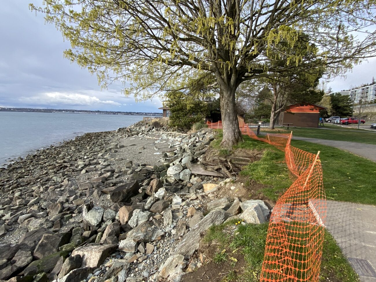
This photo shows some of the present damage to the bank of the park due to wave attack. The current project will see construction of small sections of revetment to protect existing park infrastructure in the face of sea level rise and beach nourishment to provide both protection from wave attack and provide important habitat for aquatic species.
Our work on Boulevard Park dates to 2008, but this current project began in 2022 and is expected to be complete by 2026. For more information, please visit the City of Bellingham’s project site: https://cob.org/project/boulevard-park-shoreline-and-public-access-enhancement.
Will Templeton has been working in the marine and estuarine environment since 2010 and has been a practicing coastal engineer since 2014, specializing in coastal and estuarine hydrodynamic, sediment transport, wave, and CFD modeling, design of coastal structures, and analysis and design of beaches and marshes.
Will’s experience includes analysis and restoration of shorelines in the Puget Sound and the Lower Columbia River, modeling and design of shorelines for both coastal resiliency and marsh restoration, tsunami modeling and probabilistic analysis in support of tsunami evacuation map development for Hawai’i and American Samoa, sea level rise vulnerability assessments and adaptation planning, and coastal and estuarine flood analysis and modeling.
Coastal Engineering Services
Want to learn more about our Coastal Engineering services?